
Tornado watches issued in multiple regions as storm front crosses South Carolina
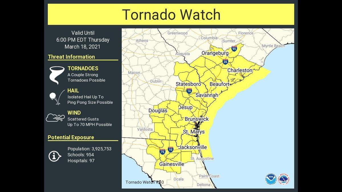
A strong storm front could bring tornadoes, damaging wind and hail to all of South Carolina on Thursday.
The National Weather Service issued tornado watches late in the day for multiple counties at opposite ends of the state.
This included much of the the Upstate and the extreme southeastern counties, where the severe weather was expected cross from Georgia into South Carolina around 2 p.m. (The watch for the Upstate expired around 4 p.m.)
“All severe hazards are possible,” the National Weather Service said.
The potential for severe weather late Thursday morning and into the evening is the result of a strong cold front that has so far spawned tornadoes across the Deep South. At least 25 suspected tornadoes were reported in six states, “from Oklahoma to Alabama,” ABC News reported.
At least 16 of the twisters were reportedly in Alabama.
While all of South Carolina faces a storm threat, regions to the far west and far east have enhanced chances for severe storms, experts say.
Timing for the arrival is 2 to 5 p.m for Allendale, Hampton, Jasper, Beaufort, Dorchester and Colleton counties. Charleston and Berkeley counties will begin to see severe weather between 3 and 6 p.m., officials said.
“There is a bit more uncertainty or less confidence in the widespread nature of the higher end significant severe threat given the latest trends,” the National Weather Service reported.
Here’s the latest:
▪ Upstate: “Heavy showers and thunderstorms are likely,” forecasters say. “A few storms may become strong to severe, producing damaging wind gusts, hail, and an isolated tornado. The greatest threat for severe will be along and southeast of interstate 85.”
A strong storm was being tracked moving west at 40 mph toward Spartanburg around 2:30 p.m., officials said. “Wind gusts up to 45 mph and dime size hail will be possible in these areas,” the NWS reported.
▪ Midlands: Rain, thunderstorms are hail are possible, mostly before 4 p.m. Gusts could be near 29 mph. Tornadoes are less likely than originally expected, but the threat of “straight-line winds” has increased, the NWS says.
▪ Coastal areas: A tornado watch is in effect for southeastern coastal counties until 6 p.m., and there is an “moderate risk” of rip currents until 8 p.m. Wind gusts could be as high as 31 mph, with an 80% chance of rain.
Multiple unconfirmed tornadoes were reported in Alabama on Wednesday. Photos posted on social media show the winds were strong enough to destroy homes. Drone video shared by The Weather Channel showed a “powerful” twister near Silas, Alabama, that caused transformers to explode.
Mud slides were reported across roads in the mountains of east Tennessee.
This story was originally published March 18, 2021 at 6:35 AM.