100% chance of rain & powerful wind forecast for the Midlands, as severe weather looms
A hazardous weather outlook was issued for the Midlands Thursday, according to the National Weather Service.
The forecast for the Columbia area shows heavy rain, thunderstorms, powerful winds, hail and tornadoes are all possible severe weather effects.
While rain started early in the morning in some areas, the showers are expected to continue throughout the day. But the severe weather is most likely to happen in the afternoon, the National Weather Service said.
The severe weather threat is not expected to end until the evening, according to the National Weather Service.
A lake wind advisory is in effect until 8 p.m., the National Weather Service said. No other advisories, warnings or watches have been issued for the Midlands, but that is subject to change.
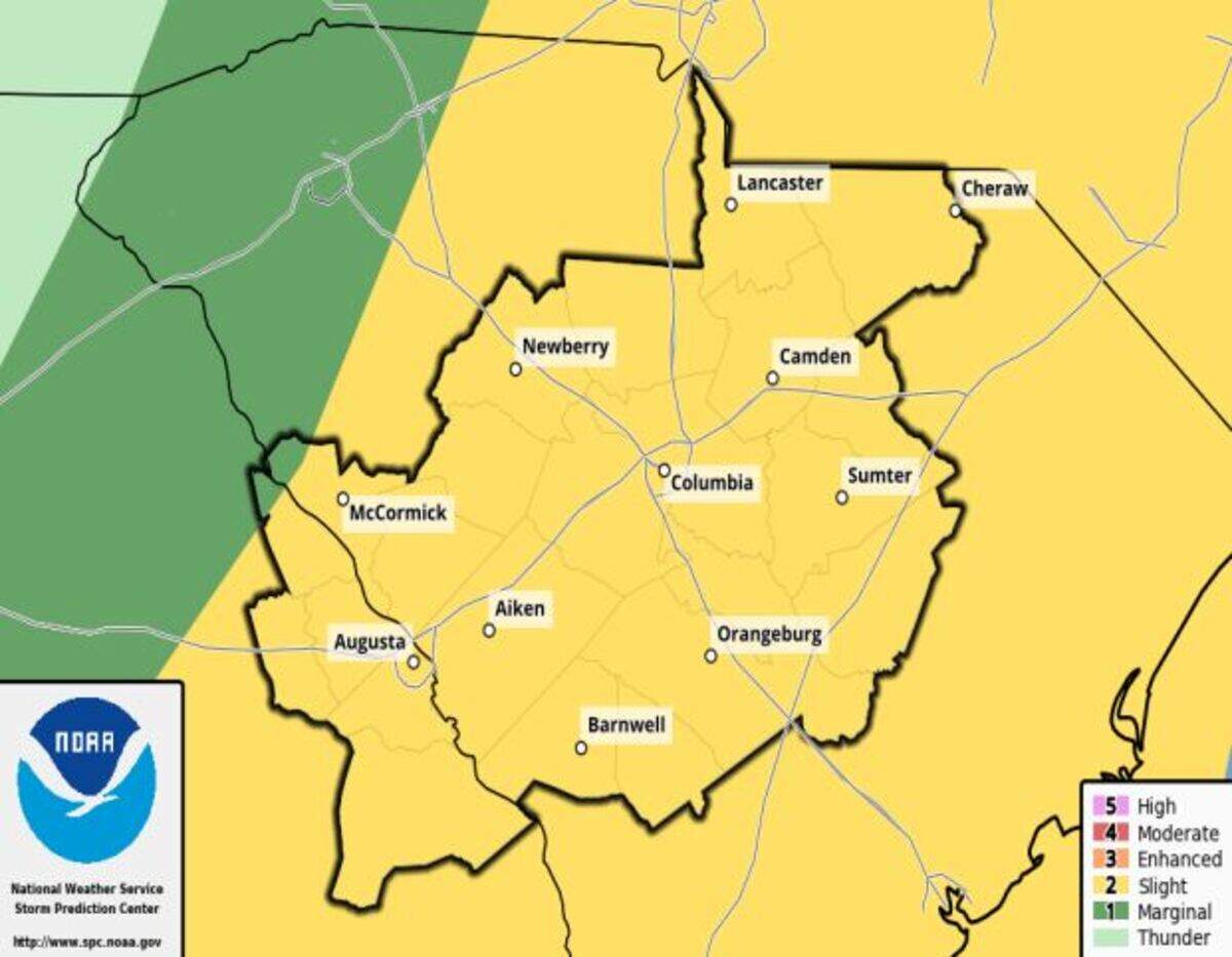
There is a 100% chance of rain, the forecast shows.
As rain and isolated thunderstorms build in intensity, damaging wind gusts will be the primary severe weather hazard, according to the National Weather Service.
Wind gusts as powerful as 32 mph are possible in the Columbia area, the forecast said.
Isolated tornadoes and large hail, from 1 to 2 inches in size, are possible, especially along Interstate 20 in the southeastern Midlands, according to the National Weather Service. But the hazardous weather outlook is in effect for all of the Midlands, including Richland and Lexington counties.
Powerful winds and tornadoes could cause considerable damage to trees and branches, in addition to mobile homes, roofs and outbuildings. Vehicles would also be under siege in the case of a tornado.
Damage to trees and branches creates the possibility of downed power lines and outages.
Up to three-quarters of an inch of rainfall is possible in the Columbia area, the forecast shows. The amounts of rain could be heavier locally, according to the National Weather Service.
Additionally, thunderstorms can produce dangerous cloud to ground lightning.
The storms are forecast to be scattered and short lived, but potentially intense, the National Weather Service said.
Quiet weather is expected behind the front, with dry conditions over the weekend through Monday, the forecast shows.
On Thursday, and into the weekend, temperatures are expected to remain steady, with possible highs in the 70s, according to the forecast.
The next storm system predicted to affect the Midlands isn’t expected until next week and will likely arrive on either Tuesday or Wednesday, the National Weather Service said.
This is a developing story, check back for updates.
BEHIND THE STORY
MOREThis is a breaking news story
In a breaking news situation, facts can be unclear and the situation may still be developing. The State is trying to get important information to the public as quickly and accurately as possible. This story will be updated as more information becomes available, and some information in this story may change as the facts become clearer. Refresh this page later for more updated information.
This story was originally published March 31, 2022 at 7:42 AM.