Tornado watch issued for portions of the Midlands as severe weather moves closer
Shortly after the National Weather Service forecast a reduced chance of widespread severe weather affecting the Midlands Thursday, a tornado watch was issued for parts of the Midlands.
At about 11:45 a.m., a tornado watch was issued for the lower portion of South Carolina, including parts of Orangeburg, Calhoun, and Clarendon counties, according to the National Weather Service.
At about 2 p.m., that was canceled, but tornado watches were issued for parts of Newberry, Saluda, Fairfield, Edgefield, Lancaster, and McCormick counties. That watch is in effect until 6 p.m., and more watches and warnings are possible as the storms move closer to the Columbia area.
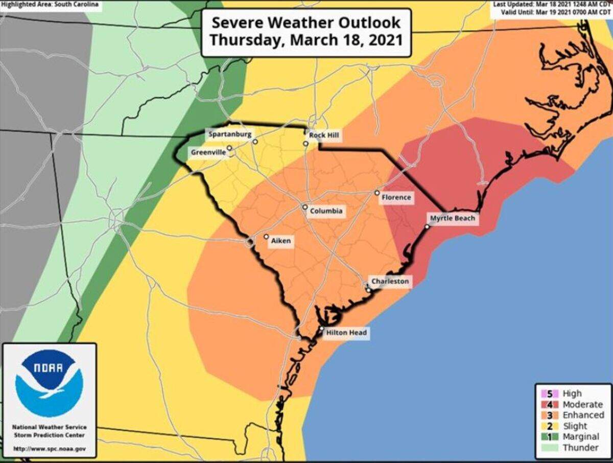
The weather service says the Midlands has an “enhanced” risk of widespread severe storms, which is a downgrade from an earlier forecast that had the Midlands as a moderate-to-high risk. Although there is lower confidence in how widespread the storms will be, there is still potential for significant severe weather in the Columbia area.
There’s still an elevated threat of tornadoes producing EF-2 or greater damage and wind gusts exceeding 75 mph, the National Weather Service said in a morning briefing. Threats include damaging winds, strong long-lived tornadoes, thunderstorms, lightning, and damaging hail, according to the briefing.
The area along and to the south and east of the Interstate 20 corridor is at the greatest risk for severe weather, specifically tornadoes, the National Weather Service said.
The exact timing of the severe weather is uncertain, but the greatest threat in the Midlands will be through 6 p.m., as the line of storms moves east, according to the briefing.
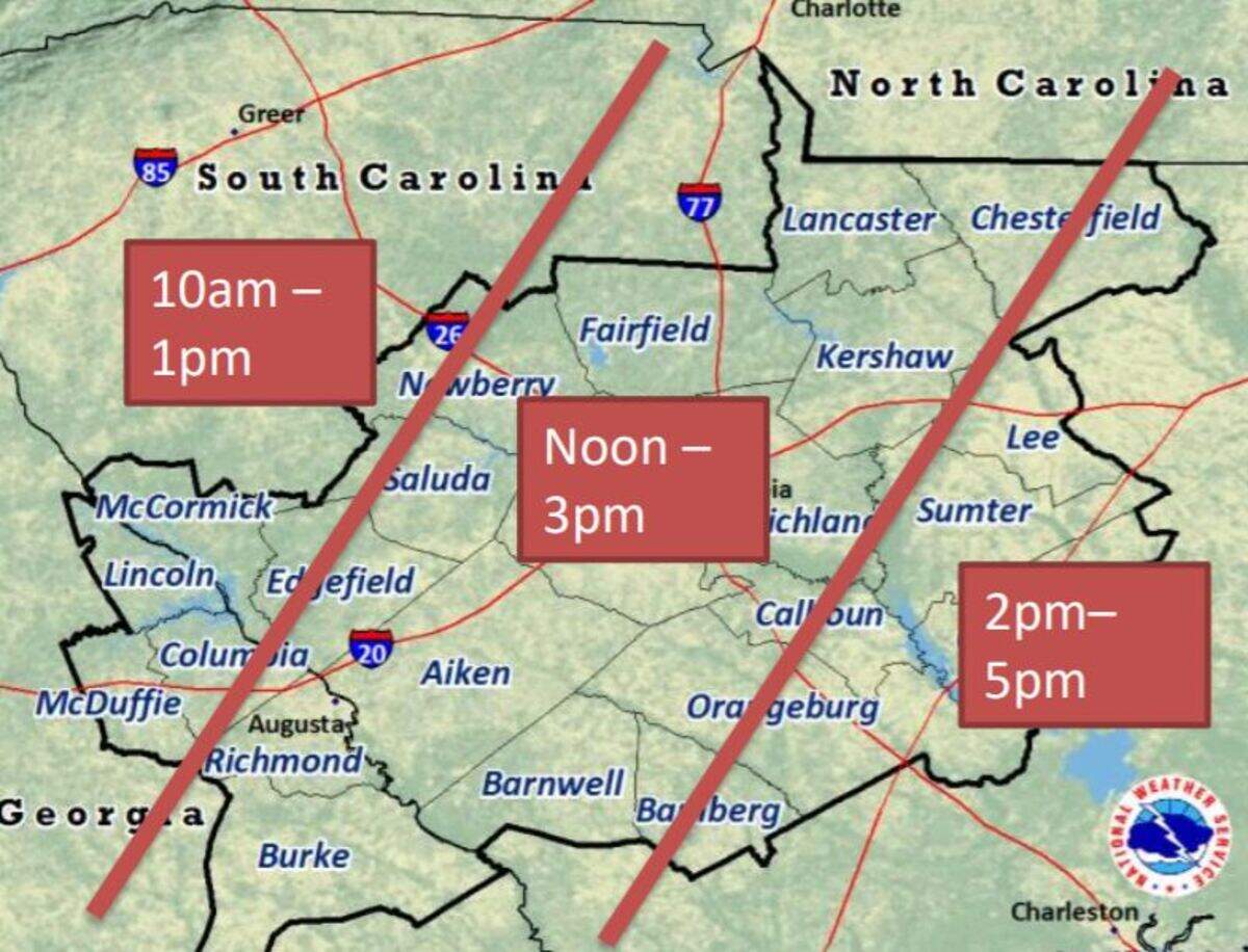
In addition to Richland and Lexington counties, the rest of the Midlands and down through Georgia is included in the briefing.
Up to three-quarters of an inch to an inch of rain could fall in Columbia by the end of Thursday night, as there is a 100% chance of precipitation, according to the forecast. Higher amounts of rainfall is possible in certain areas affected by thunderstorms, and isolated flooding can’t be ruled out, according to the forecast.
Damaging winds could cause considerable damage to trees and branches, which creates the possibility of downed power lines and outages. Tornadoes also put trees, vehicles and structures such as mobile homes, roofs, and outbuildings at risk.
The hail, which could be the size of a golf ball, can damage vehicles and roofs, according to the briefing.
In the case of a tornado, FEMA has guidelines for taking shelter. The best options of places to immediately find refuge are an above or below ground tornado storm shelter, or the interior room of a well-constructed home or building, and a basement. FEMA warned to avoid large open rooms like gyms or manufactured housing as a shelter, and said the worst places to go are mobile homes, vehicles, and underneath a highway overpass.
“Be weather aware. This is the first widespread severe weather event we’ve had this year,” National Weather Service meteorologist Chris Landolfi told The State.
Nearly a year ago, in April 2020, at least 20 tornadoes hit South Carolina in a massive storm that caused nine deaths and more injuries, in addition to damaged and destroyed property.
Temperatures could reach a high in the mid 70s on Thursday before dropping to a possible low of 48 degrees at night, according to the forecast. Cooler temperatures are predicted for the Columbia area after the storms clear out, with highs in the 50s through the end of the weekend.
By Friday afternoon no more rain is expected, and the National Weather Service said it’s going to be dry this weekend through next Tuesday.
BEHIND THE STORY
MOREThis is a breaking news story
In a breaking news situation, facts can be unclear and the situation may still be developing. The State is trying to get important information to the public as quickly and accurately as possible. This story will be updated as more information becomes available, and some information in this story may change as the facts become clearer. Refresh this page later for more updated information.
This story was originally published March 18, 2021 at 11:17 AM.